

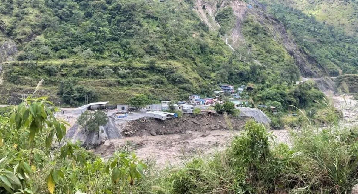
Myagdi. After the incessant rains of the second week of October, severe floods and landslides in Kaligandaki river disrupted the life of Parbat, Baglung and Mustang along with Myagdi. Riverside settlements, roads, bridges, power plants and agricultural lands were severely damaged. Some settlements were destroyed and hundreds of families were displaced. The infrastructure that had been built for years was destroyed in an instant.
Was this disaster just a result of natural events or did human intervention and carelessness increase the damage? After the Kaligandaki flood, this question has been seriously raised. According to the head of Land and Watershed Management Office Parbat, Shambhukumar Mishra, along with heavy rains, haphazard road construction, lack of proper drainage, unsafe management of stones and mud from hydropower projects and uncontrolled mining of river materials are also human factors that increase the risk of landslides.
“Previously, it rains for many days, but lately due to climate change, the amount of rain is more, but the amount of rain is more”, he said. According to Mishra, the lack of proper management of runoff on rural roads, not keeping the soil released during construction in a safe place, and excavating river materials beyond the standards have further increased the natural risk.
According to the statistics of the Department of Water and Meteorology, there was heavy rain at various rain gauges in Myagdi from October 8 to 11. 299 mm of rain was measured in the headquarters Beni, 251.7 mm in Raghuganga rural municipality-1 Beg and 236 mm in Annapurna rural municipality-6 Ratopani. In Ratopani, there was 96.6 mm of rain on October 10 and 114.6 mm in one night on October 11. 87.5 mm of rain was measured in Leyte of Mustang, 97 mm in Marfa and 58.6 mm in Jomsom. As the time of monsoon is approaching, the abnormal rainfall has increased the risk of landslides in the mountainous areas and floods in the rivers.
Seven people have died in Myagdi and two people are missing due to human loss and displacement due to landslides. Chief District Officer Ganesh Gayre said that there was damage worth billions of rupees to roads, drinking water, river control, electricity, communication, irrigation and private property. “Throughout the district, 111 houses have been completely damaged and families have been displaced”, he said, “93 houses have been partially damaged and 342 houses are at high risk of landslides.” He said that the amount of damage may increase when the collection of damage details is completed. Deputy Superintendent of Police Rajan Karki says that although the human casualties were relatively low due to precautions and preparations, there was a huge damage to the physical infrastructure.
More than 250 people have been displaced from the settlements of Paudhar, Giwang, Jharwang, Kindu, Dhaskekhar and Mahbhir of Annapurna Rural Municipality. After the weakening of the monsoon, they have started looking for empty houses of their relatives from shelters.
The local residents living in the hills and dangerous settlements are waiting for the geologist’s on-site study and suggestions. In addition to providing immediate accommodation for displaced families, long-term management of risky settlements has become a challenge. It is equally important to find a way to keep the families affected by the flood in a safe place and to prevent future damage.
Heavy damage to road and electricity infrastructure The Asoz disaster has caused heavy damage to the road and energy sector in Myagdi. Various sections of Beni-Jomsom-Korla, Beni-Baglung and Beni-Darwang-Muna roads have been damaged. After the damage to Kaligandaki Corridor of national pride and Beni-Muna-Dhorpatan road, transportation has been conducted through temporary and alternative routes. But the journey is not as easy as before.
According to Tejashwi Sharma, head of Kaligand’s Corridor Maldhunga-Beni-Jomsom-Korla Road Plan, the flood caused more than 80 million rupees worth of damage to the road structure. It is estimated that it will cost 3.5 billion to 4 billion rupees to rebuild the damaged structure. Beni-Ghasa 33 km road section, only 9 km road has completely washed away.
The flood has also damaged the 220 kV transmission line under the Kaligandaki Corridor. From Dana towards Kushma, three high-tension towers have collapsed along with their foundations, while another tower has been damaged. Due to this, about 175 megawatts of electricity produced by hydropower projects including Mistrikhola, Nilgiri, Ghalemdi and Thapakhola could not be connected to the central transmission line for 20 days.
According to Roshan Khadka, Chief and Deputy Manager of Pokhara Grid Division of Nepal Electricity Authority, after 21 days, after construction of emergency tower in Bhirkate and adoption of alternative technical measures, power supply was resumed. He said that the permanent tower construction and maintenance work has also been progressed.
The road network has reached all 45 wards of Asarmagdi due to unorganized road construction. Although the expansion of road access is positive, the risks seem to increase if the environmental aspects are not given enough attention during construction and upgrading. While widening the road, walls are cut and landslides removed. There is a tendency to throw the soil and stones from it into the ditch without managing it in a safe place. Along with the rainwater, such material gets mixed with the Myagdi, Rahughat and Kaligandaki rivers from the tributaries. The risk of landslides and erosion has also increased due to the lack of proper drainage of runoff from the rural roads.
Head of Beni-Jomsom Korla road project, Tejswi Sharma says that the haphazardly dug subsidiary and rural roads have also put the main highway at risk. “During the construction of road projects, soil management should be taken sensitively”, he said, “If the trend of digging auxiliary roads is not controlled, the problem may always recur on the national highway built with billions of investment.” While constructing the road, it is necessary to study the geological conditions of the mountains, the water drainage and the nature of the soil. The risk can be reduced if the construction materials are kept in a safe place and rainwater is drained systematically.
Soil management of hydropower projects The lack of proper management of the mud that comes out of the tunnels of hydropower projects under construction in the Kaligandaki and Myagdi river areas has also become a matter of concern. Two hydropower projects of 246 MW capacity in Kaligandaki river and five hydropower projects of 203.5 MW capacity in Myagdi river are under construction. According to local residents, the flow of the river and the coastal area may be affected if the soil and Gegran released during the construction of the project are not managed in a safe place.
Gaja Bahadur Thapa (Ratna) of Dhawalagiri Rural Municipality-7 Dharapani complained that the Myagdi river changed its course and put his 18 acres of land at risk of landslides and erosion due to the random accumulation of mud and mud from the hydropower project. Thaman Jugjali, a local resident of Bharwang, also said that environmental aspects were neglected during the construction of the project.
According to him, the trend of piling soil and mud on the river bank and letting it flow with the water has increased the amount of Gegran in the river and increased the risk of erosion in the coastal area. “The conditions of the environmental study report to safely manage the mud and mud from the tunnel have not been followed”, he said, “Due to the mud mixed with gunpowder, fish and other aquatic animals of the Myagdi River are also at risk.” During the construction of the project, it is necessary to comply with the conditions mentioned in the environmental study report and properly manage the construction materials.
River exploitation and climate change have also linked the change in the flow of the Kaligandaki River and the damage caused to the coastal area to the uncontrolled extraction of river materials. Excavating stones, gravel and sand using dozers in the river can affect the natural appearance of the river and the stability of the banks. RK Adipta Giri, an activist of the campaign to save the civilization of Kaligand, says that the uncontrolled mining of river products should be stopped.
According to him, mining will change the course of the river and the foundation of the infrastructure will be weakened and the risk of erosion will increase in the coastal settlements. “Management of materials released during the construction of development projects should also be made a mandatory part of the construction”, he said.
Kaligandaki flood has also caused great damage in Jaljala Rural Municipality-8 Farse of Parbat. According to the rural municipality, 75 houses have been completely damaged and 27 houses are at risk. A large population including women, men and children of 75 displaced families have been affected by the flood. Ramu Subedi, chairman of Farse Toll Development Association, says that the flood has entered the settlement due to the exploitation of the river. According to him, the bank of Kaligandaki river has been changed and the settlement has been damaged while excavating river materials using dozers.
On the other hand, researcher Prakash Sharma says that the flood of Kaligandaki should be analyzed in connection with the effects of climate change. According to him, the risk of abnormal rainfall has also increased in the Himalayan region where there is less rainfall due to the change in the seasonal cycle due to the increase in global temperature. Heavy rains can wash away sand, stones and silt from the steep terrain and mix with the river, which can increase the flow and cause damage to the lower coastal areas.
Sharma links environmental destruction with scholar Rob Nixon’s concept of ‘slow-motion violence’. According to him, although the impact of interference on nature is not immediately visible, it can cause great destruction over time. Poor communities living in areas prone to landslides and river banks have to bear the brunt of such destruction. “Those who benefit from the exploitation of nature can stay in safe places. But common people living in areas prone to landslides and river banks have to lose their houses, land and livelihood”, he said.
A review of the style of development is necessary. The flood of Kaligandaki has given a message that along with relief and reconstruction, the style of development construction should be reviewed. Expansion of roads, construction of hydropower projects and use of river materials are the needs of development. But the construction done by ignoring the natural geography, river flow and environmental risks can cause the destruction of the development structure itself.
Gandaki Provincial Assembly member Resham Bahadur Jugjali said that in order to reduce the damage caused by such disasters in the future, priority should be given to identification of risky areas, safe settlement development, road water management, proper disposal of construction materials and control of river exploitation. “Considering the possible effects of climate change, in addition to building infrastructure, pre-disaster information systems and local community preparedness should be strengthened”, he said.
The flood of Kaligandaki has taught a lesson that the development which ignores the limits of nature is not sustainable. Although natural disasters cannot be completely prevented, the risk of human negligence can be reduced. For that, conservation of nature, responsible development and effective implementation of laws are necessary. Otherwise, the price of negligence done in the name of development will have to be paid again by the riverside settlements and common people. -Rasus